
ViBIM Scan to BIM Services for Point Cloud to Revit Conversion
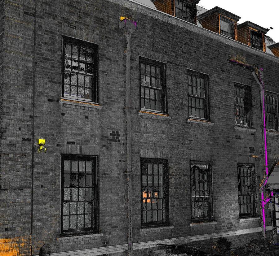
Our scan to BIM service takes the point cloud your survey team has already captured and returns an as-built Revit model of the building, checked against that scan. We work for laser scanning, survey and BIM consulting firms in the US, UK, Canada, Australia and the EU, and we do not scan on site. The core deliverable is a native .RVT file, with IFC and DWG sheets added when your project calls for them.
Four disciplines, one coordinate system
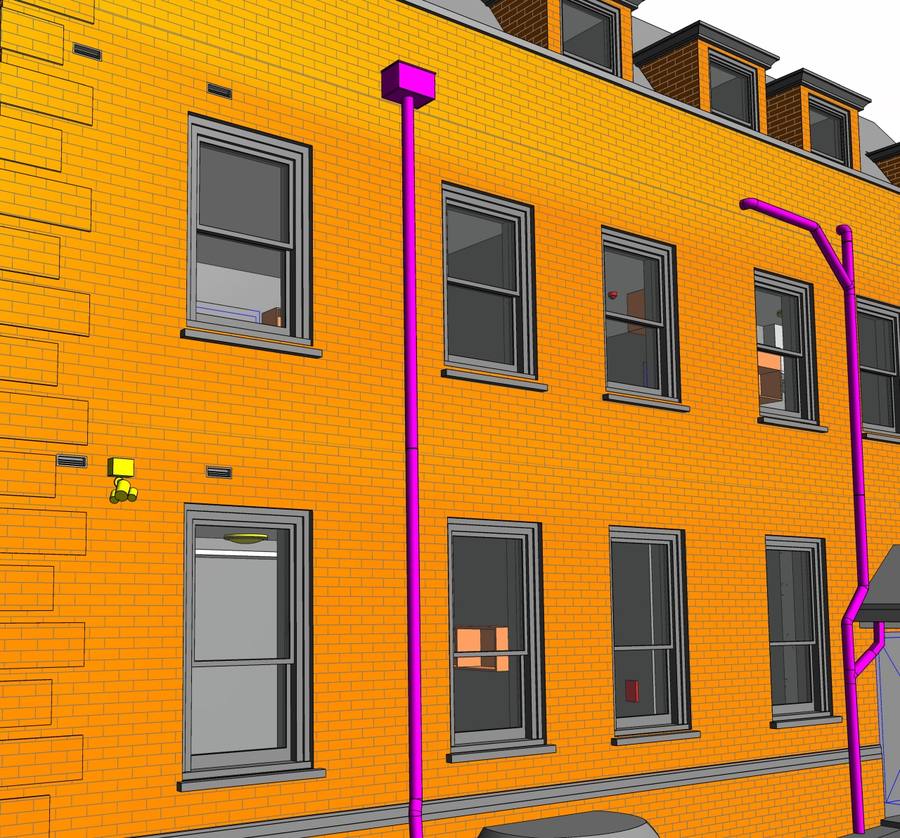
Most orders combine more than one trade. Each discipline can be bought on its own, but when two or more are ordered together they share levels, grids and origin, so the federated model lines up without manual shifting.
| Discipline | What we typically model | Usual output |
|---|---|---|
| Architecture | Walls, floors, roofs, ceilings, doors, windows, stairs, railings, decorative detail | .RVT, DWG sheets |
| Structure | Columns, beams, slabs, framing, foundations, rebar where drawings support it | .RVT, .IFC |
| MEP | HVAC and ductwork, piping, electrical and conduit, fire protection, equipment families | .RVT, .IFC |
| Topography | Hard and soft surfaces, site boundary, slopes and levels | .RVT, .DWG |
Beyond the model itself, the same registered scan can feed 2D as-built drawings, custom Revit families (.RFA) and an FM-ready model carrying asset and space data. Ordering drawings first does not lock you out of a full model later: we can build the Revit version from the identical dataset without a rescan.
Picking an LOD your scan can support
Level of Development (LOD) sets how much geometry each element carries. We deliver anywhere from LOD 100 to LOD 500, chosen per project rather than fixed per trade.
- LOD 200: approximate geometry, useful for massing, neighbouring buildings or early feasibility.
- LOD 300: precise modeled geometry, the band most of our scan-based work is ordered at.
- LOD 350: added where MEP coordination drives the job.
- LOD 400 to 500: fabrication-level detail or a field-verified record, for heritage or high-detail scope.
Two things are often confused with LOD. Level of Information (LOI) is the non-graphic data attached to an element, such as material or manufacturer, and we specify it separately. Revit's Coarse, Medium and Fine settings only change how a view displays and say nothing about how far the model has been developed.
The LOD you order also has to match the data. A registered terrestrial scan is the right source for LOD 300 and above. Mobile and handheld data, for example from a BLK2GO or NavVis unit, is less dense, so it limits how much LOD 300 detail can be modeled reliably. We still model from it; we simply flag the limit when we quote.
Files we accept and how to send them
- RCP / RCS: preferred; keep each RCS file under 5 GB.
- E57: accepted from any other scanner or software.
- Zipped datasets: one .zip per transfer for multi-file sets.
Transfer runs through FTP, Box, Autodesk Construction Cloud or Cintoo, which streams very large clouds without copying them to every workstation. Unregistered scans are fine; we register them before modeling starts. If the scan is not ready yet, we can price the job from TrueView files, site photos, Google Maps links, existing 2D drawings and a short brief, then firm up the figure once the point cloud arrives.
How a model is checked before you see it
Every project goes through two independent QC reviews against the source point cloud. Ahead of those reviews, our in-house tool flags missing, misaligned and out-of-tolerance elements automatically. Each reviewer then looks at five things:
- Geometry
- Parameters
- Deviation from the scan
- Missing elements
- Data consistency
Clash detection between trades runs in Navisworks Manage. You then review the first submission and send markups, and we return a revised model that reflects them. Our work is aligned with ISO 19650, PAS 1192 and the BIMForum LOD Specification. We do not quote a blanket millimeter accuracy figure, because how close a model sits to reality depends on scan density, coverage and registration, and on the tolerance you set.
Timeline and pricing logic
Turnaround follows estimated modeling hours, not floor area alone. As a guide, a job of 10 to 100 hours takes 1 to 4 business days, 300 to 500 hours takes 8 to 12, and the largest band, 1,500 to 2,000 hours, takes 22 to 29 business days. A typical project runs one to three weeks from approval to handover.
Price moves with six variables: disciplines and floor area, LOD and LOI, modeling tolerance, point cloud quality, dataset size and coordination complexity. We quote hourly or as a lump sum, and payment goes by SWIFT, Wise or corporate e-banking. Since 2014 we have completed more than 1,000 projects and over 250,000 hours of scan to BIM modeling, and our hour estimates draw on productivity records from comparable past jobs.
Services built on the same scan
One registered point cloud can feed several deliverables. Each item below links to the full service page on our main website, and the four disciplines also have a summary on this site.
By discipline
Each discipline has its own team lead, and one project can cover a single discipline or all four.
- Architectural Scan to BIM Services: walls, floors, ceilings, openings, roofs and facades. Summary: architectural modeling.
- Structural BIM Modeling Services: columns, beams, slabs, framing and foundations in steel, concrete or timber. Summary: structural modeling.
- MEP BIM Modeling Services: ductwork, piping, cable tray and equipment with real sizes and connections. Summary: MEP modeling.
- Topography BIM Modeling Services: terrain surfaces, contours and site context, with DWG site output. Summary: topography modeling.
By deliverable
These services sit on top of a model, either one we build from your scan or one you already have.
- As-Built BIM Modeling Services: the building as constructed, with rooms, spaces and asset data when needed. Summary: as-built modeling.
- As-Built Drawing Services: plans, sections and elevations to your title blocks, as Revit sheets, DWG or PDF.
- Revit Family Creation Services: parametric doors, windows, fixtures and equipment modeled to manufacturer geometry.
- BIM for Facility Management Services: asset data in a COBie-ready structure for CAFM or FM systems.
- BIM Collaboration Using ACC: models set up and maintained in Autodesk Construction Cloud for distributed teams.
By location
We work remotely for clients across the US, UK, Australia, Canada and the EU. Two US markets have their own pages:
- Scan to BIM Services in Texas: remote delivery for survey firms working on Texas projects.
- Scan to BIM Services in Washington DC: remote delivery for projects in the Washington DC area.
Starting a project
- Share the scan and scope with our team.
- Receive a quote covering scope of work, timeline and price within 12 to 24 hours.
- Approve, and a dedicated project manager runs the job from kickoff to handover.
Only that project manager moves your data, and we sign an NDA on request. You can read about the people doing the modeling on our team page, or see the service list above.
New clients can test us on a free trial model built from their own sample data before committing to the full scope. Send your point cloud and scope and we will come back with a trial plan and a quote within 12 to 24 hours.